
Storm drain compliance
Check every storm drain against the CPHEEO Manual on Storm Water Drainage Systems (2019): rational method flows from your IDF, velocity, Froude number, freeboard, cover and manhole spacing.
Design > Storm Compliance (SWM)... opens the Storm Drain Compliance (SWM) window. It works out the rational method flow in every drain from your IDF curve and the subcatchments, takes SWMM's peaks when there is a valid run, and checks every drain against the storm water manual. It lists every drain with a Pass, Warn or Fail verdict and colours the drains on the map by verdict while it is open.
SWM in DrainPilot means the CPHEEO (MoHUA) Manual on Storm Water Drainage Systems, Volume I Part A, 1st edition, August 2019. Some choices also cite SM, the CPHEEO Manual on Sewerage and Sewage Treatment Systems, Part A, 2013, and CL-D, the storm drainage DPR checklist in SWM Appendix A 2.1.
Run the check
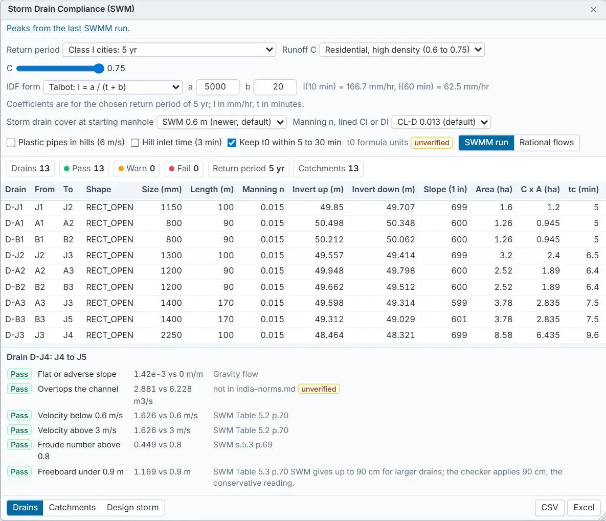
- Run the model first if you want SWMM's peaks; without a valid run the check uses the rational method flows. The line at the top of the window says which.
- Open Design > Storm Compliance (SWM)...
- Choose the Return period for the town: Class I cities 5 years, other cities 2 years, or 50 or 100 years for airports and critical infrastructure.
- Choose the Runoff C: a land use, and the C within its range on the slider, or From imperviousness.
- Choose the IDF form and type your city's coefficients, as described in Rainfall and design storms.
- Set the rule choices: Storm drain cover at starting manhole, Plastic pipes in hills (6 m/s), Hill inlet time (3 min) and Keep t0 within 5 to 30 min.
- After a valid run, choose SWMM run or Rational flows for the flows the drains are checked at.
- Read the chips (drains, pass, warn, fail, return period, catchments) and the table on the Drains tab. Click a row to see every check on that drain with its value, limit and source.
- Export the statement with CSV or Excel.
The checks
A drain's verdict is its worst check: Fail over Warn over Pass. A check that cannot be made (for an unsupported shape, say) is shown as Not checked.
| Check | Applies to | Limit | Verdict if breached | Source |
|---|---|---|---|---|
| Flat or adverse slope | Every drain | Fall greater than 0 | Fail | Gravity flow |
| Flow above full-bore capacity, or Overtops the channel | Every drain | Flow within capacity | Fail | not in india-norms.md (unverified) |
| Velocity below 0.6 m/s | Drains carrying flow | 0.6 m/s | Fail | SWM Table 5.2 p.70 |
| Velocity above 3 m/s | Every drain | 3 m/s; 6 m/s with Plastic pipes in hills | Fail | SWM Table 5.2 p.70 |
| Froude number above 0.8 | Open drains | 0.8 | Warn | SWM s.5.3 p.69 |
| Freeboard under the band value | Open drains | See the freeboard table | Fail | SWM Table 5.3 p.70 |
| Cover under 0.6 m at starting manhole | Closed conduits at the head of a line | SWM 0.6 m or SM 0.5 m | Fail | SWM s.5.4 p.79 or SM (per conflict list in india-norms.md) |
| Reach longer than the manhole spacing | Closed conduits | See the spacing table | Fail | SWM Table 11.5 p.215 |
| Catchment beyond the rational method limit | Drains whose catchment exceeds it | 8 km2 | Warn | SWM s.4.4.1.3 p.51 |
With rational flows, the capacity check compares the design flow with the drain's full capacity by Manning's equation. With SWMM peaks, a closed conduit fails it when its peak depth reaches the full height; for an open drain under SWMM peaks, the freeboard check is the one that catches a drain running too full. No d/D limit for storm conduits is confirmed in the norms, so the capacity check is marked unverified and only flags flow above full capacity.
Freeboard, open drains (SWM Table 5.3 p.70), by drain depth:
| Drain depth | Freeboard | Status |
|---|---|---|
| Up to 300 mm | 0.1 m | Verified |
| Over 300 up to 900 mm | 0.15 m | Verified |
| Over 900 up to 1500 mm | 0.3 m | Verified |
| Over 1500 mm | 0.9 m | Verified. SWM gives up to 90 cm for larger drains; the checker applies 90 cm, the conservative reading. |
Manhole spacing, closed storm drains (SWM Table 11.5 p.215), by size. The table overlaps and leaves gaps; a size it does not name takes the band below it, so it is never allowed a longer spacing:
| Size | Maximum spacing | Status |
|---|---|---|
| Up to 299 mm | 40 m | Unverified: Below 300 mm is not in the table; 40 m is carried down. |
| Over 299 up to 600 mm | 40 m | Verified |
| Over 600 up to 699 mm | 40 m | Unverified: 600 to 700 mm is a gap in the table; the 40 m band applies. |
| Over 699 up to 1050 mm | 100 m | Verified |
| Over 1050 up to 1400 mm | 150 m | Verified |
| Over 1400 up to 1499 mm | 150 m | Unverified: 1400 to 1500 mm is a gap in the table; the 150 m band applies. |
| Over 1499 mm | 300 m | Verified |
Cover at the starting manhole. SM and SWM disagree; SWM (2019) is newer. The window offers SWM 0.6 m (SWM s.5.4 p.79) and SM 0.5 m (SM (per conflict list in india-norms.md)); the newer SWM value is the default. Cover is ground level minus the pipe crown at the head of the line. A SWMM model has no separate ground level, so DrainPilot takes the manhole rim (invert plus maximum depth).
How the rational flows are worked out
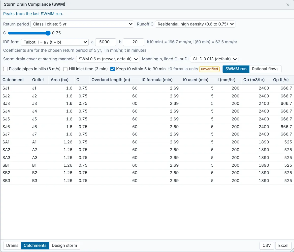
- Peak flow Qp = 10 C I A, in m3/hr, with I in mm/hr and A in hectares (SWM s.4.4.1.3 p.51), for each subcatchment draining to a node.
- The intensity I is read from your IDF at the time of concentration tc = t0 + tf.
- The inlet time t0 = 0.994 (1.1 - C) L^0.5 / S^0.333 (SWM s.4.4.1.6 p.54 to 55). L is the overland flow length, the subcatchment area divided by its width; S is its slope. The manual gives no units for this formula: DrainPilot takes L in metres and S in percent, and badges it unverified.
- With Keep t0 within 5 to 30 min ticked (the default), t0 is held between 5 and 30 minutes, or from 3 minutes with Hill inlet time (3 min).
- Going downstream, C x A adds up, and each point takes the longest time of concentration among the paths reaching it, adding the travel time through each drain at its full-bore velocity (1 m/s when that is unknown). At a node with two outgoing drains the flow is split equally.
The Catchments tab lists each subcatchment: outlet, area, C, overland length, t0 from the formula and t0 used, intensity and peak flow. The runoff coefficient ranges are from SWM Table 4.2 p.53:
| Land use | C range |
|---|---|
| Commercial | 0.7 to 0.95 |
| Industrial | 0.6 to 0.9 |
| Institutional | 0.7 to 0.95 |
| Residential, high density | 0.6 to 0.75 |
| Residential, low density | 0.4 to 0.6 |
| Recreational | 0.1 to 0.25 |
| From imperviousness | C = 0.9 x impervious share + 0.15 x pervious share, using each subcatchment's % Imperv. These two values are DrainPilot defaults, not from the manual, and are badged unverified. |
What the window can and cannot check
- Shapes checked: circular (and force main), closed rectangular, open rectangular and trapezoidal. A drain of any other shape is listed with a warning and its checks are Not checked.
- A conduit with several barrels is checked as one barrel; the window warns which ones.
- Models in US units are converted to metres and m3/s before checking.
- A loop in the network makes the flows below it incomplete; the window names the conduits that close the loop.